


Land Nav Assistant
4.1113.00 Reviews
App Specs
- Version
- 2026081710
- Updated On
- License
- $2.99
- Downloads
- 50,000+
- Developer
- Land Nav Assistant
- Categories
- Maps & Navigation
- Platform
- Android, iOS
Screenshots
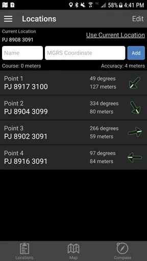
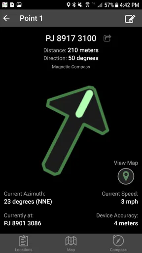
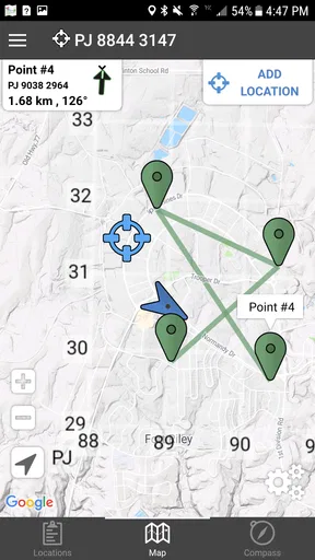
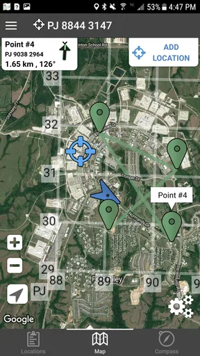
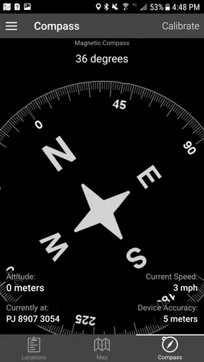
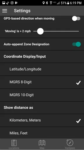
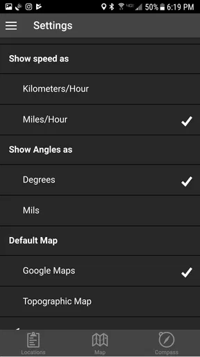
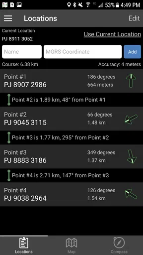
 Analysis by AppCompare
I tried Land Nav Assistant as a focused navigation tool rather than as a general map replacement, and that distinction matters. It is built around GPS navigation using MGRS and latitude/longitude, which makes it especially relevant to military-style land navigation, field training, hiking, or outdoor work where a coordinate format can be more useful than a street address. I found it most interesting when I needed to think in terms of position, bearing, and grid references instead of simply following a blue line.
The app comes from Land Nav Assistant and sits in the Maps & Navigation category. It costs $2.99, is rated for Everyone, and supports devices running Android 7.0 or later. Its current version is 2026081710, while the project itself has been available since January 23, 2012. That long presence gives it a more established feel than a brand-new field tool, although the experience is still quite specialized.
Its audience is not everybody who occasionally needs directions. If I were sending a friend across town, I would reach for a conventional map app first. If I were checking a grid coordinate during an outdoor exercise, comparing a GPS position with a paper map, or practicing MGRS navigation, this is the kind of compact utility I would keep available. The important question is not whether it replaces every navigation app, but whether its coordinate-centered approach matches the way you actually move through a landscape.
How the interface reads when attention is limited
The clearest strength is the app’s narrow purpose. Instead of surrounding the user with restaurant listings, traffic layers, business cards, and route suggestions, it concentrates on navigation information associated with MGRS and latitude/longitude. For someone already familiar with those systems, that focus can reduce distraction. You are not forced to translate a normal street-map interface into a grid reference every time you want to confirm your position.
That focus also creates a learning curve. MGRS is not immediately comfortable for every user, especially someone who has only used familiar street addresses or a visual pin on a consumer map. A coordinate display can look dense, and a person under pressure may need to understand which part represents the grid zone, which part identifies the square, and which digits describe the finer position. The app can support a knowledgeable workflow, but it does not make coordinate literacy unnecessary.
I would prepare before relying on it outdoors. Spend time comparing the displayed position with a known location, switch between the coordinate formats you actually use, and practice reading the screen without stopping to decode it from scratch. This is one of the less obvious trade-offs: a specialized display may be faster than a general map once you understand it, but slower and more error-prone while you are still learning.
Readability depends heavily on the person using the phone and on the conditions around them. Coordinate strings are visually compact and can demand careful attention. Someone with reduced vision may find a dense numerical readout harder to scan than a large map marker, while a user who prefers text and exact references may find the same information clearer than a constantly moving map. I would not judge the app’s accessibility by whether it resembles a mainstream navigation product; its strength is precision in a particular language of navigation.
Worth Reading Before You Choose

EA SPORTS FC Mobile 26 Is a Bigger Football Game, but It Takes Time

Flipboard Shows What News Apps Must Do Beyond the Feed

Switching to Android Auto Means Rethinking Your Driving Routine

Google Calendar Makes a Crowded Week Easier to Manage

Ludo King Makes the Most of the Minutes Between Plans

Baby Panda World Brings Quick Play to Modern Phones, but Its Game Library Feels Busy
There is also a useful difference between orientation and destination guidance. A regular map app is usually designed to tell you where to turn. A coordinate tool is more useful for confirming where you are and communicating that position to someone else. In a group exercise, for example, one person can report a coordinate while another checks a map or paper chart. That workflow is more deliberate than ordinary turn-by-turn navigation, but it can be valuable when everyone is working from the same grid system.
Making coordinate work easier to follow
I would keep the phone at a comfortable viewing angle and avoid trying to interpret a coordinate while walking quickly. Stop, stabilize the device, read the full value, and compare it with the map or instruction you are using. That sounds basic, but it prevents a common mistake: catching only part of a long coordinate string and moving on with a false sense of certainty.
For users who process information better in stages, it helps to separate the task into three checks: identify the coordinate format, confirm the position, and only then decide what to do next. This approach is particularly useful for beginners, people who become overwhelmed by compact numerical displays, or anyone working in a noisy group where instructions arrive quickly.
My practical advice is to treat the app as one part of a navigation setup rather than the entire setup. Pairing the phone with a printed map, a written route plan, or a simple note containing the expected coordinate gives you something to compare against. It also makes mistakes easier to spot. A phone screen can tell you what it currently reads; an external reference helps you decide whether that reading makes sense.
Different abilities, movement styles, and outdoor situations
Land Nav Assistant can be a good fit for users who prefer exact text values over visual map interpretation. Some people find a map’s symbols, colors, and changing scale difficult to parse, yet feel comfortable checking a structured coordinate. Others have the opposite preference and need a large visual route with obvious landmarks. Neither style is inherently better. The app’s inclusive value comes from offering a coordinate-first option, not from replacing every other way of navigating.
For users with motor limitations, the main question is how much precise interaction is required during a task. A coordinate workflow can reduce the need to continuously pan around a map, which may be helpful for someone who finds repeated dragging or pinching tiring. On the other hand, any small-screen interaction can become difficult when the phone is mounted, held in one hand, or used with gloves. I would set up the device before starting rather than expecting to make many adjustments while moving.
That preparation matters for people with tremors, limited reach, or reduced fine-motor control. A stable phone position and a planned stopping point can make the experience less demanding. If you need frequent route changes, rapid map exploration, or large touch targets, a mainstream navigation app may feel more forgiving. This tool makes more sense when the main action is checking a coordinate, not performing constant screen manipulation.
Users with hearing loss may appreciate that the core task is visual and coordinate-based rather than dependent on spoken instructions. In a group, a written or displayed position can also be easier to share than an audio direction in wind or traffic. At the same time, the app should not be treated as a complete communication system. If a group depends on spoken updates, hand signals, radio messages, or printed instructions, those surrounding methods still need to work independently.
For users with low vision, the experience is more complicated. A precise coordinate can be useful when enlarged through the phone’s own display settings, but a dense numerical readout may remain difficult to distinguish outdoors or in motion. I would test the app in the actual environment where it will be used, including bright daylight and low-light conditions, rather than assuming that comfortable indoor reading will translate to a trail or training area.
People with cognitive disabilities or attention-related difficulties may benefit from the app’s limited purpose, because it avoids the many unrelated choices found in a full map service. However, coordinate navigation still requires remembering a format and checking values in the correct order. A simple personal routine can help: read the format, read the coordinate, compare it with the planned area, and record it if another person needs the information. Keeping that routine consistent is more useful than trying to multitask with the phone.
A realistic outdoor scenario
Imagine I am walking with a printed topographic map during a training exercise. I stop at a trail junction, open the app, and check the current position in the coordinate format used by the map. Instead of estimating my location from a vague landscape view, I can compare the displayed reference with the grid on the paper. If the result does not match the terrain or the planned route, I have a reason to pause before continuing.
This is where the app feels more purposeful than a usual consumer map. The phone is not merely telling me to turn left at the next corner; it is helping me reconcile a digital position with a coordinate-based plan. A companion can write down the location, a team can use it as a shared reference, and I can continue using the paper map when looking at the screen becomes inconvenient.
There is a second useful scenario for outdoor workers. If I need to revisit a point later, a coordinate can be more practical than describing a location as “near the large tree after the bend.” The value is not that the app magically understands the landscape, but that it gives me a consistent positional reference that can be recorded and communicated. That is a stronger use case than casual sightseeing.
When the surroundings make phone navigation harder
Situational access is often more important than the interface itself. On a quiet desk, almost any coordinate tool is manageable. On a windy hillside, in rain, while wearing gloves, or when carrying equipment, the same task becomes slower. I would plan to stop in a safe place before checking the display, especially if the route includes uneven ground. Navigation information is only helpful if the user can examine it without creating a new hazard.
Battery management is another practical concern with any GPS-based phone workflow. I would begin with a charged device, reduce unnecessary use, and carry a backup plan for longer outings. The app may be compact, but the phone remains a phone: screen use, location services, cold weather, and poor signal conditions can all affect how confidently you can continue. A paper map and a written coordinate record are sensible companions, not signs that the app has failed.
For people who cannot comfortably hold a phone for long periods, a short check-and-record routine is preferable to constant viewing. Take the reading, note what matters, and put the device away. This is also better for users who are distracted by moving screens or who find prolonged visual attention tiring. The app works best as an instrument you consult at deliberate moments rather than as a display you stare at continuously.
Where the specialized approach still creates barriers
The biggest barrier is knowledge. A person who expects familiar addresses, recognizable landmarks, and automatic directions may open the app and wonder what to do with a coordinate. That is not a flaw in the concept, but it limits who can use it immediately. I would skip it if your main need is commuting, finding shops, avoiding traffic, or receiving spoken turn-by-turn instructions.
The second barrier is the risk of overconfidence. A precise-looking number can feel authoritative even when the user has selected the wrong format, misread a digit, or misunderstood the map reference. The app can provide a position, but the human still has to interpret it. For important outdoor work, I would verify the coordinate against terrain, a second reference, or another member of the group before making a difficult decision.
There is also a social barrier when a group uses mixed navigation habits. One person may think in latitude/longitude, another in MGRS, and a third in street-map landmarks. The app is most effective when everyone agrees on the format and on how many digits or details need to be shared. If the group has no common system, a conventional map may be easier for initial coordination, with this app used by the person responsible for precise position checks.
Its price is modest at $2.99, but value depends on frequency of use. For a person who practices land navigation or regularly works outdoors, a focused tool can justify the purchase quickly. For someone who takes two hikes a year and only wants a simple route, the usual free map options may be a better match. The audience size reflects that specialization: it has passed 50K+ installs, with a 4.1 average from 339 ratings and 113 reviews, so it is established without being a mass-market navigation choice.
How it compares with ordinary map apps
Compared with a mainstream map service, Land Nav Assistant is less about discovering places and more about understanding position. A consumer map wins for addresses, businesses, traffic, route planning, and visual context. This app wins when MGRS or exact latitude/longitude is central to the task. Trying to use one as a substitute for the other usually leads to frustration.
Compared with a paper map, the app offers a live phone-based position reference, while paper remains easier to annotate, view broadly, and use without worrying about a screen. I prefer combining them for serious outdoor navigation. The phone can answer “where am I now?” and the paper map can help answer “what does the surrounding area mean?” That division of labor is more reliable than expecting a small display to provide every kind of context.
Compared with a dedicated handheld GPS, the phone is convenient because many people already carry one, but the overall experience depends on the phone’s handling, display, and power situation. A dedicated device may be preferable for users who spend long periods outdoors and want equipment designed around that environment. This app is more appealing when you want a focused coordinate utility without adding another device to your kit.
Who I would recommend it to
I would recommend it to outdoor enthusiasts learning or using MGRS, people involved in military-style land navigation, instructors who need a coordinate reference during exercises, and hikers who already understand why a grid reference can be more useful than a street address. It is also worth considering for users who prefer exact textual information and are comfortable building a careful check-and-record routine.
I would recommend skipping it if you need a friendly first-time navigation experience, spoken guidance, public transport planning, traffic awareness, or a rich visual map of nearby places. It is not the app I would hand to a beginner five minutes before a complicated trip. The better choice in that situation is a familiar map application paired with a simple route plan.
The Everyone content rating makes it broadly suitable from an age-category perspective, but suitability in practice still depends on the user’s navigation training and the responsibility of the outing. A child can use a coordinate display in a supervised learning activity, yet an adult should not assume that an age rating means the tool teaches safe navigation by itself.
My inclusive verdict after using it
Land Nav Assistant supports inclusion best by giving a specialized alternative to visual, address-based navigation. It can suit people who communicate through coordinates, prefer structured text, or find a general map app too cluttered. It can also reduce repeated map gestures in some workflows. Those are meaningful advantages, especially when the user prepares the device, understands the coordinate system, and uses the app alongside a wider navigation plan.
Its limitations are equally clear. Dense coordinate information can challenge users with visual processing difficulties, unfamiliar terminology can exclude beginners, and outdoor conditions can make phone interaction awkward for people with motor or sensory needs. I would test it in the real setting, agree on a coordinate format with companions, and keep a non-phone reference available. That approach makes the tool more accessible without pretending it solves every access need.
My final view is positive but specific: this is a practical coordinate companion, not a universal map replacement. The $2.99 purchase makes sense when MGRS or latitude/longitude is part of your regular outdoor routine. If that language already feels natural to you, the app’s focused design can be genuinely useful. If you want effortless directions and broad visual context, choose a conventional navigation app instead. For the right user, its simplicity is the point; for everyone else, that same simplicity may feel like a wall.
Pros
- Works offline
- making it useful in remote areas without mobile coverage.
- Supports multiple coordinate formats for varied navigation needs.
- Clear map and compass tools are helpful for field navigation.
- Waypoint management makes it easy to mark and revisit important locations.
- Useful for hiking
- camping
- hunting
- and outdoor training activities.
Cons
- Some advanced features may require time to learn and configure.
- Map accuracy depends on the available data and device GPS performance.
- Continuous GPS use can drain the phone battery quickly.
- The interface may feel dated compared with newer navigation apps.
- Limited usefulness in dense urban areas where traditional land navigation is unnecessary.
FAQs for Land Nav Assistant
What is Land Nav Assistant used for?
Land Nav Assistant is designed to help users with outdoor navigation, especially when working with maps, coordinates, bearings, routes, and waypoints. It can be useful for hiking, camping, field training, hunting, surveying, and other activities where understanding your position and moving accurately between locations is important. It should be treated as a navigation aid rather than a complete replacement for map-reading skills or official navigation equipment.
Does Land Nav Assistant work without an internet connection?
The app’s offline usefulness depends on the maps and data available on your device. GPS positioning can generally work without mobile data, but online map layers, satellite imagery, address searches, weather information, or other connected features may require internet access. Before heading into a remote area, users should open the required maps, test the main tools, and confirm that the necessary content is stored locally.
Can Land Nav Assistant calculate bearings, distances, and coordinates?
Yes, the app is intended for practical land-navigation tasks such as viewing coordinates, measuring distance, determining direction, and working with waypoints or routes. These tools can make field navigation easier, particularly when you need to compare your current position with a destination. However, results depend on GPS reception, map accuracy, device sensors, and how carefully the information is entered.
Is Land Nav Assistant accurate enough for hiking or military-style land navigation?
Land Nav Assistant can be helpful for recreational hiking and structured navigation practice, but accuracy is affected by your phone’s GPS hardware, environmental conditions, terrain, tree cover, buildings, and the quality of the selected map data. It should not be the only navigation method in demanding or safety-critical situations. Carry a physical map, compass, backup power, and another reliable way to determine your location.
What permissions and equipment does Land Nav Assistant require?
The app will normally need location permission to display your position and support navigation features. Depending on the tools you use, it may also request access to storage, files, or network connectivity for maps and saved data. A phone with a functioning GPS receiver is essential, while a compass sensor can improve directional guidance. Review permissions carefully and keep your battery charged before using the app outdoors.


